One of the fun parts of dynamics is that it is the gift that just keeps on giving. There can be thousands or more little eddies, whorls and shears in a dynamic flow. It takes a really smart person to figure each and every one out and an idiot to think that they can. Since I am not the sharpest tack in the box, I look to get close enough not exact. That would be anal.
So the puzzle today is a rainy forest. Since trees create their own temperature inversion with a cooler forest floor than canopy, the puzzles involves the temperature difference below and above the canopy. If there is a 5 degree cooler floor and the air is saturated enough that the dew point just happens to be 5 degrees cooler than the canopy, what happens as the entire layer becomes saturated?
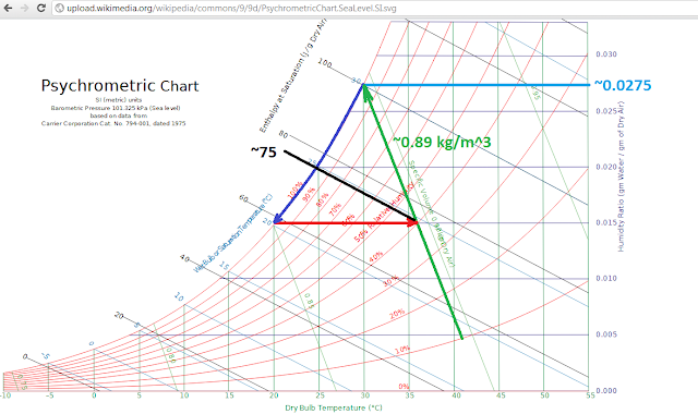
If we make the forest a tropical rainy one, the psychrometic chart might look something like this. The canopy is about 35 C and around 75% relative humidity, saturation is 5 C lower or 30 C, and we would have a cycle kinda like a poorly designed gas turbine.
To make things simpler, imagine that the forest is big, say 500 or more kilometers on one side and as deep as you like.


Could you please clarify your question? E.g. you say what happens when T > T - 5 -- what does it mean?
ReplyDeleteAlso, how does the y dimension play in here? We can think of circulation systems that are symmetric in the third dimension (like hurricanes can be considered axisymmetric).
there are a few differences between a forest example and a hurricane example. The forest has a natural temperature inversion. The canopy temperature is 5 to 10 degrees warmer than the floor. As a storm starts, the canopy temperature T would reduce towards the saturation temperature, T-5 in this case.
ReplyDeleteAnother is that a hurricane is a radial storm and a forest more like a frontal storm. If you think of a rectangular orifice, then y would be large and x would be like the thickness of the plate. It would impact the dynamics more than in a hurricane example.
You seem to imply that when the storm starts, the canopy temperature will drop such that there will be no temperature gradient between the ground and the cloud base. This is possible. It will produce a negative horizontal temperature gradient such that u.∇T < 0 (if we started from horizontal isothermal surface). I.e. there will be a negative temperature difference between condensation area and surrounding regions. This will enhance condensation (because the air streaming towards the storm will approach saturation not only because of vertical ascent but also because of the horizontal temperature drop).
ReplyDeleteNot sure what your other considerations concerning geometry are about (certainly I agree that forest is not a hurricane not only because of geometry, but because of roughness), but thank you for your interest.
Anastassia, because of the roughness there would be an impact caused by the depth or y dimension. It should tend to break up the system into cells which would feed other cells, kind of like what you see over the Amazon. I think that your theory is pretty sound, just that it needs to recognize individual cases to be accepted.
ReplyDelete