New Computer Fund

Saturday, January 31, 2015

Laboratory versus the Real World

Since I suspect that the Herbert et al. tropical SST reconstruction data using UK'37 will require some re-calibration, I am becoming a Mg/Ca kinda guy, I looked for a few comparisons using the same core or region.  DuBois et al. used the Herbert method and LuDuc et a. did a comparison of UK'37 and Mg/Ca.

Nothing is simple though.  The lat/lon are the first two numbers in the legend with the core identifier and method.  From the read me with the DuBois 2009 data we have this:

Cores ME0005A-27JC, ME0005A-43JC and TR163-31P were analyzed for alkenone unsaturation at Dalhousie University following standard laboratory procedures detailed by Kienast et al. (2006), whereas cores TR163-19P and TR163-22P where analyzed at Brown University following similar laboratory procedures detailed by Herbert et al. (1998). 
The age models for these cores were adopted as published in earlier studies (ME0005A-27JC from Kienast et al. 2007, ME0005A-43JC from Benway et al. 2006, TR163-19P from Lea et al. 2000, TR163-22P from Lea et al. 2006, TR163-31P from Martin et al. 2002). 
The alkenone unsaturation index UK037 is calculated as UK'37 = (C37:2)/(C37:3 + C37:2), where (C37:2) and (C37:3) are concentrations of the diunsaturated and triunsaturated C37 methyl alkenones. For conversion into temperature estimates, we used the culture calibration of Prahl et al. (1988) (UK'37 = 0.034T + 0.039). Replicate analyses of selected samples indicate an analytical precision of about ±0.01 UK'37 units (0.3°C). 

So we have lab quality of about +/- 0.3C but real world temperature ranges of about +/- 3.0 C degrees.  The eastern tropical Pacific should be about the worst case.  There is a great deal of ENSO related upwelling and northward circulation.  The UK'37 method can be "calibrated" to regional temperatures but you may not be able to capture the variance.  So while the eastern Pacific is an interesting region, temperature reconstructions are going to be a beyatch.  So let's just say Eastern Tropical Pacific is going to be put on hold.


Thursday, January 29, 2015

Favorite Ocean Paleo Proxies


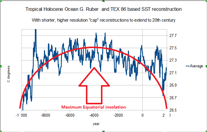
My favorite is becoming the Mg/Ca (g. ruber.) pretty quickly.  Instead of the standard spaghetti chart this is something a bit different.  This is just all the Marcott et al. selected reconstructions for the central tropical region combined in one big time series.   This gives you an eye for the variance in the individual proxy reconstructions versus a roughly 100 initial to 500 year smooth back near 13000 BP.   Since this doesn't include "caps" or the most recent data for the core locations, there is a "hockey stick" starting around 800 years before present.  The "caps" are all pretty much in the orange noise so the variance here is not a bad indication of the overall confidence interval.  If these were all thermometers, you could reduce the error range but paleo "bugs" can have biases so there is some question about how much you can reduce the error bars.

I like the Mg/Ca because they appear to produce more realistic temperatures more often.


The Uk'37 and TEX 86 are alkenone based "thermometers" seem to have issues figuring out if they are "surface" or "subsurface" temperature indicators.  While there where not many southern tropical reconstructions selected by Marcott et al. the ones selected have a much higher variation.  Near the Pacific coast that variation could be real with changing currents or it could be "bugs" going with the flow from colder waters with the currents.   That is useful, but I would think a serious ocean current model would be required to take advantage of these.  TEX 86 though seems to be mainly a fresh water thing.  The Teirney et al Lake Tanganyika reconstruction which is included in this group, so it not a "true" SST reconstruction, is responsible for the more noticeable peaks.

It has a number of spikes that are likely related to the precessional cycle.

There are more northern tropical reconstructions in the Marcott et al. selections and these tend to be in better agreement.  Not a huge difference between Glacial and Inter-Glacial in the northern tropics it would seem.

If I combine all the reconstructions, since the central equator has more recons it tends to dominate.  You get the same hockey stick shifted toward 300 years BP.  Since the UK37 recons tend to run a little on the cold side the variance is much larger.


As I said at the start this isn't your standard reconstruction but I think it does show potential uncertainty better than you will normally see.  btw, the last combines all the reconstructions listed on the first three charts.

Here is the complete list.

Number Location / Core Reference


1 GeoB5844-2 Arz et al., 2003 (4)
2 ODP-1019D Barron et al., 2003 (5)
3 SO136-GC11 Barrows et al., 2007(6)
4 JR51GC-35 Bendle and Rosell-Melé 2007 (7)
5 ME005A-43JC Benway et al.,2006 (9)
6 MD95-2043 Cacho et al., 2001 (10)
7 M39-008 Cacho et al., 2001 (10)
8 MD95-2011 Calvo et al., 2002 (11)
9 ODP 984 Came et al., 2007 (12)
10 GeoB 7702-3 Castañeda et al., 2010 (14)
11 Moose Lake Clegg et al., 2010 (15)
12 ODP 658C deMenocal et al., 2000 (16)
13 Composite: MD95-2011; HM79-4 Dolven et al., 2002 (17)
14 IOW225517 Emeis et al., 2003 (18)
15 IOW225514 Emeis et al., 2003 (18)
16 M25/4-KL11 Emeis et al., 2003 (18)
17 ODP 1084B Farmer et al., 2005 (20)
18 AD91-17 Giunta et al., 2001 (21)
19 74KL Huguet et al., 2006 (22)
20 74KL Huguet et al., 2006 (22)
21 NIOP-905 Huguet et al., 2006 (22)
22 NIOP-905 Huguet et al., 2006 (22)
23 Composite: MD01-2421; KR02-06 St.A GC; KR02-06 St.A MC Isono et al., 2009 (24)
24 GeoB 3910 Jaeschke et al., 2007 (25)
25 Dome C, Antarctica Jouzel et al., 2007 (26)
26 GeoB 7139-2 Kaiser et al., 2008 (27)
27 Dome F, Antarctica Kawamura et al., 2007 (28)
28 18287-3 Kienast et al., 2001 (29)
29 GeoB 1023-5 Kim et al., 2002 (30)
30 GeoB 5901-2 Kim et al., 2004 (31)
31 KY07‐04‐01 Kubota et al., 2010 (32)
32 Hanging Lake Kurek et al., 2009 (33)
33 GeoB 3313-1 Lamy et al., 2002 (34)
34 Lake 850 Larocque et al., 2004 (35)
35 Lake Nujulla Larocque et al., 2004 (35)
36 PL07-39PC Lea et al., 2003 (36)
37 MD02-2529 Leduc et al., 2007 (37)
38 MD98-2165 Levi et al., 2007 (39)
39 MD79-257 Levi et al., 2008 (39)
40 BJ8 13GGC Linsley et al., 2010 (40)
41 BJ8 70GGC Linsley et al., 2011 (40)
42 MD95-2015 Marchal et al., 2002 (41)
43 Homestead Scarp McGlone et al., 2010 (42)
44 Mount Honey McGlone et al., 2011 (42)
45 GeoB 10038-4 Mohtadi et al., 2010 (43)
46 TN05-17 Nielsen et al., 2004 (44)
47 MD97-2120 Pahnke and Sachs, 2005 (45)
48 MD97-2121 Pahnke and Sachs, 2006 (45)
49 17940 Pelejero et al., 1999 (46)
50 Vostok, Antarctica Petit et al., 1999 (47)
51 D13822 Rodriguez et al., 2009 (48)
52 M35003-4 Rühlemann et al., 1999 (49)
53 OCE326-GGC26 Sachs 2007 (50)
54 OCE326-GGC30 Sachs 2007 (50)
55 CH07-98-GGC19 Sachs 2007 (50)
56 GIK23258-2 Sarnthein et al., 2003 (51)
57 GeoB 6518-1 Schefuß et al., 2005 (52)
58 Flarken Lake Seppä and Birk, 2001; Seppä et al. 2005 (53, 54)
59 Tsuolbmajavri Lake Seppä and Birk, 2001; Seppä et al 1999 (54, 55)
60 MD01-2390 Steinke et al., 2008 (56)
61 EDML Stenni et al., 2010 (57)
62 MD98-2176 Stott et al., 2007 (58)
63 MD98-2181 Stott et al., 2007 (58)
64 A7 Sun et al., 2005 (59)
65 RAPID-12-1K Thornalley et al., 2009 (60)
66 NP04-KH3, -KH4 Tierney et al., 2008 (62)
68 GeoB6518-1 Weijers et al., 2007 (64)
69 MD03-2707 Weldeab et al., 2007 (65)
70 GeoB 3129 Weldeab et al., 2006 (66)
71 GeoB 4905 Weldeab et al., 2005 (67)
72 MD01-2378 Xu et al., 2008 (68)
73 MD02-2575 Ziegler et al., 2008 (69)
Update: Here is a semi-random mix of tropical recons.

This is mainly eastern tropical Pacific which I used with no particular plan in mind (semi-random).  Other than the "cap" recons there aren't that many that were missed by Marcott et al. 2013, other than some of the longer, low frequency recons.  Some of those have clusters of higher frequency data points around interesting events like the LGM and the Younger Dryas.  Including those will play hell with estimating confidence intervals.  This chart though has the average scale on the right (note I have the ledges reversed) and the average on the right.  I was going to trash this but figured I might as well post it so it is saved from my next round of playing.

Tuesday, January 27, 2015

Part of the See Saw with some Paleo Issues


Part of the Hemispheric See Saw and the shift from 41ka to 100ka glacial cycle shift is a tough nut to crack.  Herbert et al. produced a tropical ocean reconstruction with some part going back over 3 million years.  The Atlantic core they used had some issues so there is a major gap, but the Arabian Sea, South China Sea and Eastern Pacific looked pretty good.  Liu and Hebert also published this 1.8 million year reconstruction of the Eastern Pacific, which I have interpolated and binned to 1kyr for some other stuff I am doing.  Open Office doesn't have a nifty interpolation routine for sporadic paleo core time series so I cludged this together.  Not great, not bad.

"Many records of tropical sea surface temperature and marine
productivity exhibit cycles of 23 kyr (orbital precession) and
100 kyr during the past 0.5Myr, whereas high-latitude
sea surface temperature records display much more pronounced
obliquity cycles at a period of about 41 kyr. Little is
known, however, about tropical climate variability before the
mid-Pleistocene transition about 900 kyr ago, which marks the
change from a climate dominated by 41-kyr cycles (when ice-age
cycles and high-latitude sea surface temperature variations were
dictated by changes in the Earth’s obliquity) to the more recent
100-kyr cycles of ice ages. Here we analyse alkenones from marine
sediments in the eastern equatorial Pacific Ocean to reconstruct
sea surface temperatures and marine productivity over the past
1.8Myr. We find that both records are dominated by the 41-kyr
obliquity cycles between 1.8 and 1.2Myr ago, with a relatively
small contribution from orbital precession, and that early Pleistocene
sea surface temperatures varied in the opposite sense to
local annual insolation in the eastern equatorial Pacific Ocean.
We conclude that during the early Pleistocene epoch, climate
variability at our study site must have been determined by
high-latitude processes that were driven by orbital obliquity
forcing."


This is their abstract that accompanies the data at NCDC paleo. 


When I compare the tropical reconstruction with the solar insolation, the best correlation I get is with the Equatorial peak as I have mentioned in previous posts.  Of all the tropical reconstruction I have seen, the Eastern Pacific has the largest cooling trend for the past million years actually starting around 2.7 million years ago.  I believe that is due to flow increasing through the Drake Passage and prior to that, Antarctic ice could clog the passage during SH glaciation/de-glaciation some what, but erosion possibly reduced the chances of a major blockage over time.  
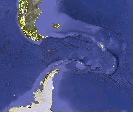
This Google Earth image shows the scouring pattern and the volcanic island ring at the outlet.  Ice blockage would reduce flow and it could divert flow making it very difficult to figure out what is happening.  That is one of the reasons I abandoned the Southern Oceans because there is just to0 much going on for it to be a fun problem.
Back when I was looking at the Southern Oceans I noted the similar scouring at the former Panama gap. They are similar enough that I would believe that massive ice sheets were responsible for both. Whether or not that is the case, both were likely major regulators of ocean circulation. When ocean water can flow more efficiently to the polar heat sinks that would tend to reduce average ocean heat capacity and SST. When the SH glaciation was able to expand northward more, the tropics would show a stronger obliquity cycle signal, ~41ka and without that they can synchronize with weaker signals in multiples of ~10ka +/-2ka or the rectified equatorial precessional cycle. You end up with roughly the eccentricity cycle related glacials, but since eccentricity is pretty weak, the frequency can shift back to 41ka or even ~21ka, the regular old precessional cycle beat.

Since the precessional cycle is influenced by glacial mass throwing things out of balance, a uniform SH glacial mass would tend to reduce wobble which could alter the precessional frequency.  That is pretty much the case since "Wobble" has just about stopped.  What that means in the future I have no clue.  I just suspect that you can't count on any regular ice age pattern to be predictable. The Holocene could last another 20 thousands years if something doesn't change things.


The point of this post though is the temperatures recorded by Lui and Herbert seem to be about 2 degrees lower than they should be.  Lea et al. 2007 is a reconstruction off the Galapagos which is very close to the same location and has a temperature closer to what I would expect.


It indicates close to 25 C during the Holocene peak.


The Reynolds satellite data for that area is around 28C.  SST as I have mentioned before is a bit confusing since what the actual skin temperature is isn't what is being measured by buckets, intakes or plankton.  Since the convective triggering is around 28 C, cold oceans in the tropics would not produce the energy needed to build ice sheets, so something appears to be amiss.  A bit of a stumbling block as far as what I a doing in any case.


This is the issue, z, meters per bug type.  The G. Ruber white and pink are your normal "surface" temperature proxy.  They over lap with a range according to Farmer et al. 2007 from 0 to about 39 meters. 39 meters is a huge range for "surface" temperature depth readings.  This is wet suit instead of shorty range depending on the time of year.  The N. Tumida bug likes a 175 to 275 depth range so it is used for "sub" surface temperatures.  Most every living organism has a temperature preference so the same bug in the higher latitudes would tend to be shallower than in the tropics.  You also have variations in ocean currents that would move bugs from one location to another.  So if current direction changes, and most often it will, you would have bugs from a different temperature zone from time to time settling to the bottom when they croak.

This is one reason I prefer the Indo-Pacific Warm Pool and other locations that would tend to have less current variability.  None of this is new to the paleo world, but the confidence intervals are based on how well they measure what is deposited and not always on issues that impact the depositing.  So when Herbert et al. note they have +/-0.2 C temperature accuracy, they are talking about their lab quality not their core quality.  

All this means is that when I put together a tropical ocean reconstruction using various cores I am not going to provide confidence intervals that don't mean diddly.  I am just going to provide the mean or average with the binned and interpolated data with what some might consider a "handwave" at confidence.  It is better to be honest than over confident doncha know?


This is more a PostIt note than a real serious post, but for the loyal followers of my blog, all both of them :), I thought I would throw it up.  

By the Way, Proper citation for anything you lift from this blog is, "Some Redneck Posted ..." or you can get into more detail if ya like.


Update: a good example

ACK!  These are Eastern tropical SST reconstruction all close to the equator.  There is seven degree C difference between the coldest and warmest.  The longer term recons are by Lea et al. and the shorter ones by Stott et al.  Now if I use these, I am going to have to re-calibrate if I hope to get a reasonable approximation of actual SST.  


And here we have 5 million years of sub-surface temperatures for the same region.  That is a huge swing for this region even over 5 million years.  So there is going to be a lot of double checking and weeding out of recons that will just end up causing "cherry picking" accusations.  


Monday, January 26, 2015

Tropical Convective Triggering Potential


Deep Convection, the seriously bad ass thunder storms are a part of my life on the water and one of those question marks in Climate Model scenarios.  I ran across a GFLD paper a while back that I unfortunately cannot find at the moment that discussed convection triggering temperatures over land based on available soil moisture.  That paper used 27.5 C as the trigger temperature but the few marine based studies I have seen are using >28 C degrees.  It is only a half degree, but both seemed low in my opinion.  Down here I don't have much t'storm issues around 82 F surface water temperatures and even joke about not diving if there ain't an 8 in front of the temperature.  Around 85 C I tend to have my hands full dodging storms, unsuccessfully a bit more often than I like, So I was thinking 29 C would be the go to number.  The more open oceans rarely get over 30 C without hammer head clouds building like crazy.  Average, SST for the tropics tends to be currently in the 27.5 C range and there is evidence of increased cloud feedback, so I am a bit more impressed with the GFLD number after that consideration.

So in addition to instrumental temperatures and the Oppo 2009 IPWP reconstruction I often use, this Solar orbital cycle thing kinda forced me to do some stuff I had been putting off.

This is an extension of the tropical temperatures by close to a million years.  The "average" temperature is about 24.2 C and the control or triggering temperature average appears to be about 25.5 C.  Since that "average" is over about 1000 years roughly, a more "realistic" tropical mean would be in the 27.5 C range.  If that is the case, the way I have the solar insolation could be about right, meaning clouds limit temperature, increased clouds would increase pole ward advection of moisture which would increase high latitude snow, building glacial expanse, etc. etc.

That is just a guestimate though and the numbers on the chart are questionable.  They do provide a rough reference though.  The Langleys/day aren't something I normally use but were used in the Berger et al. Solar cycle construction.  You can divide by two to get a ballpark of Wm-2 change, but I am using peak, not average, so an average fan might want to do it hisself.

In either case, this orientation of solar and my quick and dirty combination of the Herbert et al. 2010 data as noted, would indicate cloud regulation of SST as being pretty likely.  I will revisit this reconstruction in the future as I will revisit this one.


This one uses over a dozen of the Marcott et al. 2013 Holocene recon which I have modified for a "tropical" perspective.  It is unfinished so I am not going to dig out all the attribution stuff again at this moment,  Marcott et al. supplemental data is just a Google way. This indicates around 28 C as a tropical SST Holocene "norm which is comforting to me as it is.  Comforting to me is an indication of my current confirmation bias that I will have to check later.

So I would guess that cloud regulation starts around 27.5 C and really kicks in around 28.5 C. Looking back at the million year reconstruction you could add 2 to 3 degrees to the values Herbert et al. came up with.  That is not a slight of Herbert et al., the same ocean cores they use are sometimes used for mid and bottom water temperature, so their values may be closer to thermocline temperatures than real "surface" temperatures.  One of the issues I have with instrument SST records is that the "absolute" temperatures recorded by ocean engine raw water intakes can be a degree or so lower than the surface temperature the sky "sees", that skin layer issue.

The Reynolds oiv2 tropical SST data shows about the same 28 C peak from the 1980s.  So climate models might use >28 C for a "control" aka triggering temperature.  Actual local temperatures would vary of course, but it seems like the right number.


The red line charts are from Climate Explorer in case you are wondering.


Now that is all great, we have a control range for one thing.  What about other stuff?


Besides the nice smooth rectified tropical energy envelope you have occasional spikes.  I used Equator June but you could pick any month at any latitude to figure out which spike causes the most grief.  Biological and Glacial Mass for that matter are a PITA.  Instead of simple too much or too little you can have too much just right.  Biological organisms can reproduce themselves out of the game.  Glacial mass can get too heavy.  Because of this you can develop a few dozen possibly hundreds of fairly valid theories.  Every damn one will have some exceptions.  Every damn one that is carefully put together will have some validity.  To model "everything" correctly you have what would look like a simple equation with constants that aren't really constants.  They would be deceptively complex partial differential equations with each factor considered with respect to every other factor at every possible "critical" point.  You can simplify most but there are critical levels where at least one that is normally insignificant rears its ugly head.

You can call that Chaos or get a grip and call it reality.  An Earthquake or Volcano caused by glacial mass distorting the Earth's crust is  just one of those normally insignificant details.  Iso-static rebound triggering Earthquakes and Volcanoes that cause abrupt cooling and the growth of glacial mass another of those typically insignificant details.  Massive algae blooms depleting oxygen and producing so much sulfur compounds that everything croaks, another minor detail.  Trust me, there is plenty of job security in science.


Update on the South China Sea.


Steinke et al. have two 2006 and 2008 submissions on the South China Sea.  There are always dating issues and the UK 37 issues with the bugs being on the "surface" and currents changing etc.;  Their work may indicate that Herbert et al. 2010 has one or both of the issues.  28C makes more sense because of convective trigger, at least to me, so if I do "adjust" Herbert 2010 for a long term tropical reconstruction, this is what I will probably use for the South China Sea part.

The Eastern Tropical Pacific is more of a challenge due to ENSO impacts on currents.  For the Indian Ocean/Arabian Sea portion there appears to be plenty of reconstructions.  The Atlantic will have about as many issues as the Eastern Pacific.

Sunday, January 25, 2015

Solar Cycles and Ice Ages - Let's Move on Already.

Willis has another post on Solar Cycle forcing over at Watts Up With That, the Ice Box Heats Up.  He is using the same data, 65N (0r 60N) insolation and different methods and coming up with about the same results.  Imagine that?  He can probably do a couple hundreds of posts using the same data and different methods and come up with about the same result.  I would even expect it is "likely" he will continue using the same data and different methods and come up with about the same results.

65N is and above is about 3% of the global surface and last I check we live on a sphere. When Milankovitch proposed his orbital theory of the Ice Ages he decided that 65N was the go to insolation band to support his theory.  Thanks to that 65N has a comfortable place in climate science tradition even thought it tends to cause problems with Milankovitches theory.

I am borrowing Willis chart to show part of his new twist.  first difference of 60N insolation.  This choice was prompted by a paper he read in defense of Milankovitch.  It shows the same pretty much hap hazard correlations.

This is my chart of Berger solar insolation done in a way someone concerned with energy in the system would do it.  The Average for the whole sphere and the peak energy in the firebox, the tropics.   This does not included the adjustment for ocean surface area, what I am more concerned with, just the gross Peak values.  The "Tropical" region, 30S-30N is roughly 50% of the global surface area, so I would expect the 0 Peak to contribute about 50% of the variation in temperature.  That would fill the "gaps" in the ~20 kyr precessional cycle.  It is like a bridge rectifier conditioning the signal.

Now if we stick with the electrical analogy, ocean heat capacity would be similar to a battery which would help filter the output of the bridge rectifier.

 Since there are a lot of nice scientists doing all sorts of scientific stuff, it isn't hard to find paleo reconstructions of temperature.  Saraswat and company produced one of the Indian Ocean in 2005 and kindly archived the data at NCDC paleo.  In this particular case I, first have year instead of kyr and second have scaled Langleys/day.  That scaling would represent how much energy that thin ten degree band of the equator would contribute to "global" ocean energy.  It is not an exact indication of anything.  It would be just a scaled signal and you can imply anything you like, but that would be roughly the contribution of the equatorial band as provided by Berger et al.to "global" ocean energy.  I haven't vetted, verified or homoginized my rough estimated as It is a work in progress like most things on my plate.

With the rectification, you should expect any combination of frequencies in multiples of 10 kyr +/- 2 kyr.  There is no need to "explain" the lack of 100,000 year Milankovitch frequencies because there is a perfectly good reason to expect 90kyr, 100kyr, 110kyr etc. etc. etc. because the "system" responds to the "forcing".


I had posted these previously, using the same equatorial peak though without the scaling.  The numbers come from the sources, all archived on NCDC paleo if you are that bored or I can even upload a spread sheet for the deranged that are into nits.  The point is that the Equatorial Signal is an important factor and the 65 or 60 N signal, a not so important factor.  Milankovitch was right but left some unfinished business for his new age critics.

I didn't use Willis" Huyber's geological time source and don't care to because I have other irons in the fire.  I also don't have meticulous attention to citing detail because all of this is just a Google away.  If anyone is concerned with solving problems instead of creating them, I am more than happy to provide as much detail as time will allow.

Saturday, January 24, 2015

That Solar Orbital thing Again

I created a brief post on my opinion of how solar orbital forcing on the oceans specifically for paleo reconstructions, Solar Precessional and Ocean Heat Uptake.  I really wanted it to be "brief" because I didn't want to go through all the crap needed to "prove" a correlation that I knew existed but wasn't sexy enough to blow people's minds.  But since there are people that want to dig deeper I created a quick and dirty example.


This is a comparison of an Indian Ocean temperature reconstruction by Saraswat et al. 2005 that is available from the NOAA NCDC paleo website for anyone wanting to replicate and Equatorial solar orbital forcing variation created by Berger A. and Loutre M.F., 1991, also available at NOAA NCDC website.  If you want to duplicate this "exactly" you will need to figure out the percent of the total ocean area by 10 degree latitude band in order to ratio the solar variation.

The correlation between the reconstruction and solar at the equator is ~50%, with total solar (85S-85N) 43% and ex-arctic (60N-60S) 42%.  That would be what I would call a "fair" correlation given all the issues with coarse paleo reconstructions.  This will not blow wind up most folks skirts, but it isn't all that bad really.

The solar is based on "peak" values not average as explained in the post I linked to some extent.  There is way too much going on in the climate system and paleo to expect a perfect correlation but about half would be better than many would anticipate.  The correlation is based on 130 points if that is something you would like to know for some "significance" verification.  Be aware though that I had to "bin" the IO recon to 1ka points to match the solar data which would influence the correlation somewhat.


This is what the "global" and "wet" ocean solar insolation curves look like. "Wet" would be 60S-60N which is generally ice free.

Be also aware that the spread sheet size can get a bit cumbersome so it would be better to do some real programming if that is your thing. The moral though is that "The Sun Done about half of it if not more."

Update:  Here is another one.


That is the Arabian Sea reconstruction by Herbert, T.D., L.C. Peterson, K.T. Lawrence, and Z. Liu. 2010 with the full equatorial peak insolation using Berger et al.  I think it is a good correlation but I didn't bin a million years worth of data to find out how good.  

Friday, January 23, 2015

The Solar Precessional Cycle and Ocean Heat Uptake


I posted this work in progress tropical ocean reconstruction with the red precessional cycle curve on a blog and received a comment that you don't see solar insulation curves on most paleo reconstructions.  You don't because there is a 65N maximum insolation bias.  Glacial and interglacial  cycles hinge on ice and 65N maximum insolation has the largest impact on ice which tends to accumulate up around 65N.

That is fine.  However, we are not in a 65N maximum solar insolation cycle we are closer to a maximum 65S solar insulation cycle or about 10,000 years later in the game.  With the exception of the poles where the "endless day" effect of axial tilt creates a large variation in "average" solar intensity, no one much cares since the equatorial average doesn't vary much.  That would go back to the TSI/4 A$$trophyicist TOA insolation estimate.  As I have pointed out before, TSI/4 is perfectly appropriate for TOA or a rock planet, but not so much for a liquid planet.  For a liquid planet you need to consider subsurface penetration which leads to a TSI/pi() alternate approximation.  TSI/pi() is a thermodynamic consideration which needs more consideration for a more accurate estimate.  If the surface loses energy at a very high rate, you may as well go with TSI/4, but if there are sufficient lags in heat transfer, TSI/pi() is more accurate.  You basically have a valid range if you consider both.

 I wasn't going to get into this, since I am having more fun with the cloud regulation thing but this chart is based on ocean area and the precession of the equinox.  For a 30 degree insolation cone you would have maximum solar intensity on the largest area of ocean mid- precessional cycle.  For a 60 degree cone, maximum is closer to the southern tropics.  The 60 Degree cone, +/-30 degrees would have a minimum insolation of 87% of maximum and the 30 degree cone 97% of maximum.  You of course have cloud response which would reduce local insolation, but you have potential values in any case.  If the absorbed solar takes longer than a year to work its way out of the system, the peak solar insolation is what you need not "average".

You can look up density gradient solar pond design to get all of the things needing to be considered, but on a planetary scale, TSI/pi() is close enough for a rough estimate.  Then how much lower actual temperature is compared to TSI/pi() gives you an estimate of all those other considerations that some will say you were too lazy to figure.

As a by the way, when glacial mass is at a maximum, open ocean area is at a minimum.  Most of the world beaches have a gradual slope so if sea level is 100 meters lower, you would lose a lot of ocean area.  This would change correlations a bit.

In a high sea level world, "global" surface temperature would correlate more closely to tropical SST.  In a low sea level world, "global" surface temperature would correlate more closely with glacial area i.e. northern hemisphere surface temperature.  This is the main reason that high latitude tree rings are a waste of time if you are looking for "current" global temperature proxies.  They would be the go to proxy close to 65N max insolation, but not 65S max insolation.

Lat 1410Wm-2 °C 1361Wm-1 °C 1312Wm-2 °C d(wm-2) max dT max
25 352.0 7.6 339.8 5.1 327.6 2.5 24.5 5.0
20 376.8 12.4 363.7 9.9 350.6 7.3 26.2 5.1
15 397.1 16.1 383.3 13.6 369.5 11.0 27.6 5.2
10 412.0 18.8 397.7 16.3 383.4 13.6 28.6 5.2
5 423.5 20.8 408.8 18.2 394.1 15.6 29.4 5.2
0 434.1 22.7 419.0 20.0 403.9 17.4 30.2 5.3
-5 444.2 24.4 428.7 21.7 413.3 19.0 30.9 5.3
-10 449.4 25.2 433.8 22.6 418.2 19.9 31.2 5.3
-15 448.8 25.1 433.2 22.5 417.6 19.8 31.2 5.3
-20 442.1 24.0 426.7 21.4 411.4 18.7 30.7 5.3
-25 432.3 22.3 417.3 19.7 402.2 17.1 30.0 5.3

Using the area percentage and TSI/pi() you can make a table of Sea Sub-Surface Temperatures.  The difference between max and min insolation averages around 29Wm-2 and 5C which should be close to the change in SST from glacial to interglacial, "all else remaining equal" which is never the case. You have to remember though that while one region has one extreme, the opposite end of the world has the other except for the equatorial peak/valley.  At the equator things would be less variable but you would have peaks every half precessional cycle.  That would limit the range of temperature to about half of the maximum range or about 2.5 C degrees.  


  This Lake Tanganyika reconstruction by Tierney actually shows the changes better than ocean reconstructions because it doesn't have the complex thermohalide circulation to deal with.  When there is lots of glacial mass you don't "see" the precessional cycle ocean influence, but when the oceans are warm, the oscillations stand out fairly often.  Another issue is that when the oceans are warm the cloud cover increases.  Lake Tang thought is very close to the TSI/pi() estimated temperature and clouds generated by Lake Tang would tend to have less impact on the lake itself because it is relatively small and isolated.  

So does TSI/pi() and precessional impact on ocean area "solve" climate modeling issues?  No way.  It does provide  different direction to attack the problem though.


Update.

I was looking for a spread sheet I have for estimating precessional cycle solar variation, but it is locked up tighter than Dick's hat band.  So I opted for a NOAA data set that includes all orbital variations pretty Much, but it is Langleys/day.  The plot above is for the equator peak annual insolation.  It is not an annual average but the peak value for any month of the year.  Most of the time you would see a June value and a nice oscillating curve.  Using TSI/pi() though this is the curve you want to use.  Notice how this looks more like ice core temperature reconstructions that fiddle fart matching varying oscillations with occasional peaks and valleys.  If we lived on a water only world, the temperature record would look a lot more like this.  We don't though we live on a mainly water world that tanks to land mass distribution would like to become an ice world from time to time.  The average variation is around 40 Langleys per day which would be roughly 20 Wm-2 variation or about 3 C at the equator.

To do this right I would need to do all the conversions and get the peaks by latitude band etc. etc., but since there is latent and clouds to consider it would be pretty much a waste of time without a more serious model.  For now this is all I need and should show you why a precessional cycle should be "seen" in tropical Holocene reconstructions.

Since I started this Willis has a post on WUWT so you can pop over and compare a nail driver's approach to an HVAC guys approach :)


Why not 65S?

Since that question was asked here is an update.  There is more ice variation in the high northern latitudes.  Antarctica is thermally isolate and there isn't much other land area down there to grow glaciers on.  You would use the solar intensity that is most likely to trigger abrupt change in the Glacial/interglacial situation.  As I said the right way to be using each latitude band but since I am focusing on Ocean Heat Uptake due to precessional cycle changes I am going to concentrate on the bands most likely to influence ocean heat uptake.

This compares Equator, 60N and 60S peak insolation.  If I pick a ocean temperature reconstruction from any of those bands I would expect to see some sign of the precessional cycle.  The high latitudes can trigger ice sheet collapse, mainly in the NH but once in a great while in the SH which impact ocean circulation and sea level, but most of the energy absorbed by the ocean still comes from the tropics.  These curves include all orbital variations, but I am concerned with the Precessional change.


Precessional produces the higher frequency, ~20ka full cycle and ~10ka equatorial half wave.  Axial tilt would vary the intensity of the precessional insolation making in more likely for a glacial to interglacial transistion, but that only happens every 2 to 3 tilt cycles and isn't very consistent.  That is because ice sheet stability involves more factors than just solar intensity.

Since you are not going to get a perfect correlation because of differences in internal and solar dynamics, my approach is to start with the simple cycle impact on the primary atmospheric heat source, the oceans and work out from there.


So "doing it righter", orbital impact on ocean energy would look something like that ex-cloud albedo of course.  In any case, orbital influence should be a sanity check for paleo-climatologists so they don't smooth out the real signals.

Update:  Since it is windy and a bit chilly for me today I bit the bullet and played with the Berger et al, solar data for the whole million years.  This comparison of a million years of Arabian Sea SST produced by Herbert et al. in 2010, or at least the data was archived in 2010 at NCDC with the Peak equatorial insolation as determined by Berger et al. show just what should be expected.

We have a "fair" correlation.  So I would give Herbert, T.D., L.C. Peterson, K.T. Lawrence, and Z. Liu. 2010 a high five for high quality work.  Though I would mention to K. T. Lawrence that more stuff on the seesaw would nice to see :)

Since the Vostok Composite CO2 record was pretty easy to bin, here that is with Equatorial Solar.  The correlation as noted on the chart was 25%.  Interestingly there is the same 400ka weirdness.